AI in Action: Advanced Public Health Modeling to Forecast Disease Outbreaks Using Geospatial AI
Discover how AI is revolutionizing public health by accurately predicting disease outbreaks. This blog explores cutting-edge research, combining geospatial ai, satellite imagery, machine learning, and environmental data to tackle malaria and cholera across Africa. Learn how these innovations save lives, drive more innovative interventions, and shape global health's future. Dive in to see the transformative power of AI in action!
SCIENTIFIC INSIGHTS INTO AI AND GEOSPATIAL TECHNOLOGIESTECH FOR PUBLIC HEALTH
Scott Pezanowski
1/5/20257 min read

Imagine a world where we can predict disease outbreaks with the same precision as weather forecasts. What if public health agencies could anticipate the subsequent malaria or cholera hotspot weeks and deploy resources to save lives before the first case emerged? This vision is becoming a reality thanks to the transformative power of Geospatial AI. By integrating advanced machine learning models, Earth observation data, and geospatial analysis, we are revolutionizing how diseases are predicted, understood, and managed across vast regions.
Here, we explore cutting-edge research on how geospatial AI is applied to disease modeling in Africa—a region of immense diversity and complexity—and what this means for public health, science, and business.
The Importance of Geospatial AI in Public Health
Every year, diseases fueled by environmental factors such as air pollution, water contamination, and climate change claim millions of lives. According to the World Health Organization (WHO), nearly one in four deaths globally can be linked to environmental conditions. Add the infectious diseases spread by humans, animals, and insects—many of which thrive in specific ecological niches—and the challenge becomes staggering.
Traditional public health tools often struggle to connect the dots between environmental, demographic, and disease data. This is where geospatial AI leverages advanced computational techniques to find patterns and predict outbreaks before they happen. By incorporating high-resolution satellite imagery, climate models, and population density data, geospatial AI enables public health experts to tackle epidemics with unparalleled accuracy.
The question isn’t whether we can improve disease prediction but how quickly we can implement these solutions globally to protect the most vulnerable communities.
Behind the Research: Predicting Disease Across Africa
Why Africa?
17 million sq km
1.1 billion
people
in size
Africa’s sheer geographic and cultural diversity presents unique challenges and opportunities for disease prediction. The WHO African Region spans over 17 million square kilometers, encompassing more than 1.1 billion people, thousands of districts, and various climates and ecosystems. Disease dynamics here are influenced by tropical rainfall, population density near water bodies, and urbanization trends.
WHO African Region
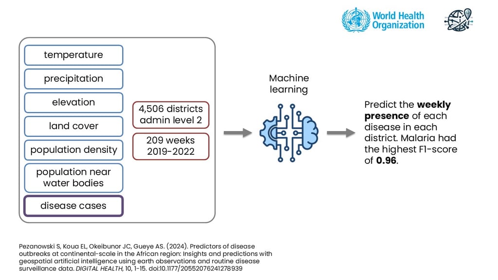
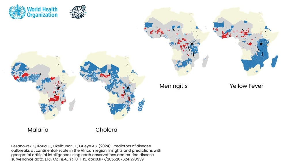
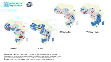
This study focused on predicting weekly disease cases for four major illnesses—malaria, cholera, meningitis, and yellow fever—at the district level. Researchers chose this granularity to preserve local-level insights while scaling analysis to continental dimensions.
Methodology: Combining Data and AI
The Datasets
At the heart of this research was the WHO’s Integrated Disease Surveillance and Response (IDSR) dataset, which tracks weekly suspected cases of various diseases across Africa. To enrich this data, researchers integrated:
Environmental Data: NASA’s precipitation and temperature datasets.
Land Cover Information: Satellite-based vegetation classifications, water bodies, and built-up areas.
Population Metrics: High-resolution data on population density and proximity to water bodies derived from OpenStreetMap.
These datasets were combined into a comprehensive geospatial database, preserving temporal (weekly) and spatial (district-level) scales.
Analytical Techniques
The research combined traditional spatial analysis with state-of-the-art machine learning techniques:
Spatial Autocorrelation Analysis: Methods like Moran’s I and Local Indicators of Spatial Association (LISA) were used to identify disease clusters and hotspots.
Computational Advancements
The use of AutoML significantly reduced the time needed to identify optimal models, allowing researchers to focus on interpretation and real-world applications. Furthermore, scalability was a core feature, as the methods developed can process massive datasets and rerun predictions as new data becomes available.
Machine Learning Models: Algorithms such as Random Forest and LightGBM were trained to predict whether a district would experience cases in a given week. AutoML tools were employed to optimize the model selection, ensuring the best results.
Key Findings: What We Discovered
Spatial Relationships Are Crucial
The analysis revealed that spatial proximity matters significantly for disease transmission. For example, districts near malaria hotspots were more likely to report cases themselves. Similarly, cholera cases clustered around water bodies, highlighting the role of environmental factors in disease spread.
Environmental Drivers
The study uncovered key environmental factors influencing each disease:
Malaria: Strongly associated with tropical climates, tree cover, and elevation.
Cholera: Closely tied to proximity to water bodies and rainfall patterns.
Meningitis: Influenced by dry climates and seasonal temperature changes.
Yellow Fever: Predominantly found in savanna regions with unique spatial clusters.
Machine Learning Performance
Malaria predictions achieved an impressive F1 score of 0.96, indicating high accuracy. However, diseases with fewer cases, like yellow fever, presented challenges due to data imbalance. These results underscore the importance of robust data collection for all diseases to improve model reliability.
Time Matters
Temporal trends emerged as a critical predictor. Diseases often follow seasonal or cyclical patterns—malaria cases peak during rainy seasons, while meningitis outbreaks correlate with dry periods. Understanding these trends allows for better resource allocation and timely interventions.


Hotspot Insights
Using Local Indicators of Spatial Association (LISA) revealed intriguing patterns. For example, the Great Lakes region of Africa exhibited distinct hotspots for malaria and cholera, with complex interactions between environmental and demographic factors. These insights are invaluable for targeted interventions.


Implications for Public Health, Science, and Business
Public Health: Targeted Interventions
The ability to predict disease outbreaks at a local level has profound implications for public health planning. Governments and NGOs can use these models to:
Pre-position medical supplies and vaccines in high-risk areas.
Deploy health workers to potential hotspots before outbreaks escalate.
Optimize the allocation of resources to save lives and reduce costs.
Science: Advancing Epidemiology
This research represents a significant step forward in epidemiological modeling. Combining geospatial analysis with machine learning sets a new standard for disease prediction. The scalability of these methods means they can be applied globally, extending beyond Africa to address health challenges in Asia, the Americas, and beyond.
Business: Opportunities in Health-Tech
The commercial potential of Geospatial AI in health is immense:
Insurance: Predicting disease risks could refine health insurance models, reducing costs for both providers and customers.
Pharmaceuticals: Companies can use predictions to optimize supply chains for vaccines and treatments.
Tech Startups: Developing AI-driven health dashboards and real-time prediction tools offers untapped opportunities for innovation.


Challenges and Opportunities for Improvement
Data Gaps
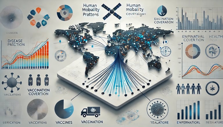
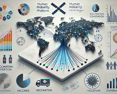
While the IDSR dataset is robust, certain diseases suffer from underreporting or inconsistent data collection. Expanding surveillance efforts and integrating additional datasets, such as vaccination coverage and human mobility patterns, could enhance prediction accuracy.
Real-Time Capabilities
Currently, the analysis relies on historical data. Developing real-time dashboards powered by AI could provide actionable insights during outbreaks, enabling faster responses.
Advanced Modeling Techniques
Future studies could incorporate time-series analysis to capture temporal patterns better. Exploring deep learning models like recurrent neural networks (RNNs) might also unlock new predictive capabilities.
Although this research focused on Africa, the methodology is adaptable to other regions. Applying these techniques to South Asia or South America, where environmental factors similarly drive disease dynamics, could yield global insights.
Expanding Geographic Focus
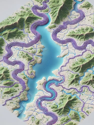
One fascinating finding of this research was the complex spatial dynamics around Africa’s Great Lakes region. This area exhibited distinct disease patterns, with malaria hotspots near water bodies and unique cholera outliers. Such insights highlight the importance of focusing on regional characteristics when developing public health strategies. Future research in this region could incorporate additional factors, such as urbanization rates and economic activities, to refine predictions further.
Additionally, by leveraging satellite data and advanced geospatial modeling, researchers can simulate interventions, such as improved sanitation or vector control programs, to assess their impact on disease reduction in this high-risk area.
Case Study: The Great Lakes of Africa Region
A Vision for the Future
As geospatial AI continues to evolve, its applications in public health are boundless. Imagine a future where:
Disease dashboards provide real-time outbreak predictions.
AI-driven simulations allow policymakers to test scenarios like vaccination campaigns or climate change impacts.
Global collaboration leverages these tools to tackle pandemics and endemic diseases alike.
This vision requires collaboration across sectors. Scientists, public health officials, tech developers, and policymakers must work together to scale these innovations and ensure their benefits reach the most vulnerable populations.
Conclusion: Let’s Shape the Future Together
Geospatial AI is not just a tool; it’s a transformative force for good. Integrating environmental, demographic, and disease data empowers us to predict outbreaks, allocate resources efficiently, and save lives. The work in collaboration with WHO demonstrates what’s possible when cutting-edge technology meets real-world challenges.
But the journey is far from over. The potential to expand these methods globally, incorporate new datasets, and build real-time systems means the best is yet to come. If you’re as excited about this future as we are, let’s connect. Whether you’re a researcher, a policymaker, or a business leader, you have a role in this mission.
👉 Watch the full video here about predicting disease outbreaks with geospatial AI.
Together, we can revolutionize public health and build a healthier!
