Analyzing Place-Time-Attribute Info in Twitter Analysis
Discover how our analysis of place-time-attribute information in Twitter tweets can reveal where conversations are happening. This social media analysis has significant potential for outbreak detec...

Video 1: SensePlace2: Visual Analytics and Big Data for Spatiotemporal Sensemaking.

Video 2: SensePlace2 Functionality – October 2012.

Video 3: SensePlace2 – Geo Twitter Analytics.
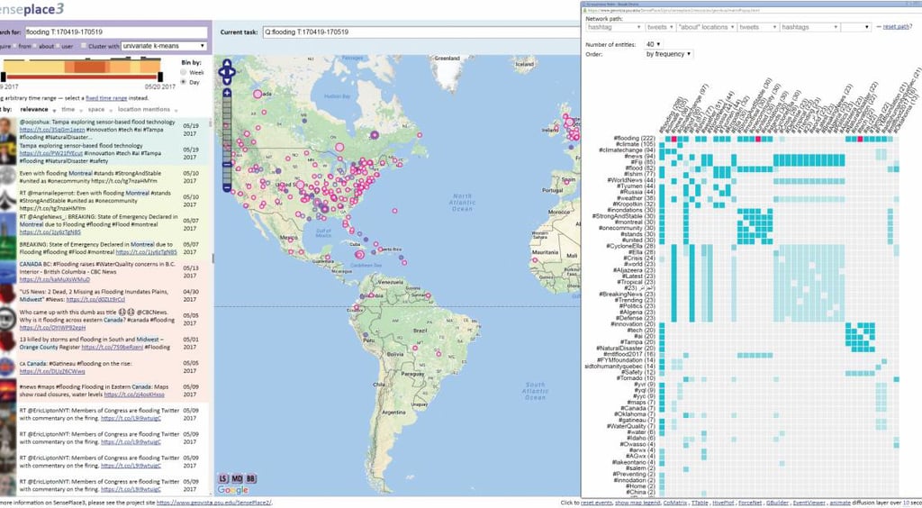
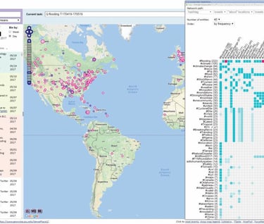
SensePlace2 / SensePlace3 was a project I collaborated on as a researcher at The Pennsylvania State University. Collaborators were in the Geography Department, the College of Information Sciences and Technology, and the Computer Science and Engineering Department. This project was funded by the US Department of Homeland Security (DHS) and the US Army Corps of Engineers Research and Development Center (ERDC), Geospatial Research Laboratory. We aimed to analyze place-time-attribute information in Twitter tweets and make sense of places from millions of tweets. Not only did we build a social media analytics system to map and analyze the small percentage of tweets where the user enabled their location, but we also led the way in analyzing the places mentioned in the tweets. Our work was one of the first to describe using tweets and their location data for emergency situational awareness. It also led to meaningful discussions in the research and emergency response communities of the ethics of location-based data in crises.
Accolades
SensePlace2/SensePlace3 was recently selected for the Institute of Electrical and Electronics Engineers (IEEE) Visual Analytics Science and Technology (VAST) Test of Time Award presented at the 2021 IEEE VIS Conference. Specifically, our article SensePlace2: GeoTwitter analytics support for situational awareness from 2011 was awarded. My colleague, Dr. Anthony Robinson, gave the acceptance speech below.

Video 4: IEEE VAST 2021 Test of Time Award acceptance speech.
The award committee members – Brian Fisher, Shixia Liu, Catherine Plaisant (chair), Jonathan Roberts – chose our article because: The paper has over 400 citations, and is still regularly cited today as an early example of visual analytics for aggregated social media data. Published when Twitter was still ramping up, the paper described using tweets and their location data for situation awareness during emergencies. It includes a survey of emergency practitioners and a valuable discussion of situation awareness. This work led to important discussions of the ethics of location-based data in crises. SensePlace2/SensePlace3 produced many other academic research publications. The publications that we contributed to are listed below.
Pezanowski, S., MacEachren, A. M., Savelyev, A., & Robinson, A. C. (2017). SensePlace3: a geovisual framework to analyze place–time–attribute information in social media. Cartography and Geographic Information Science, 00(00), 1–18. https://doi.org/10.1080/15230406.2017.1370391
MacEachren, A. M., Savelyev, A., Pezanowski, S., Robinson, A. C., & Mitra, P. (2014). Report on New Methods for Representing and Interacting with Qualitative Geographic Information, Stage 2: Task Group 3: Social-focused Use Case. http://www.dtic.mil/get-tr-doc/pdf?AD=ADA618993
Savelyev, A., MacEachren, A. M., Pezanowski, S., Karimzadeh, M., Luo, W., Nelson, J., & Robinson, A. C. (2014). Report on New Methods for Representing and Interacting with Qualitative Geographic Information, Stage 2: Task Group 4 Message-Focused Use Case. http://www.dtic.mil/get-tr-doc/pdf?AD=ADA622198
Savelyev, A., Pezanowski, S., Robinson, A. C., & MacEachren, A. M. (2012). Report on Component 2-Designing New Methods for Visualizing Text in Spatial Contexts. http://www.dtic.mil/cgi-bin/GetTRDoc?Location=U2&doc=GetTRDoc.pdf&AD=ADA580753
Robinson, A. C., Savelyev, A., Pezanowski, S., & MacEachren, A. M. (2013). Understanding the utility of geospatial information in social media. ISCRAM 2013 Conference Proceedings – 10th International Conference on Information Systems for Crisis Response and Management, 918–922. http://www.scopus.com/inward/record.url?eid=2-s2.0-84905656005&partnerID=tZOtx3y1
MacEachren, A. M., Jaiswal, A., Robinson, A. C., Pezanowski, S., Savelyev, A., Mitra, P., Zhang, X., & Blanford, J. (2011). SensePlace2: GeoTwitter analytics support for situational awareness. VAST 2011 – IEEE Conference on Visual Analytics Science and Technology 2011, Proceedings, 181–190. https://doi.org/10.1109/VAST.2011.6102456
MacEachren, A. M. . M. a. M., Robinson, A. C. ., Jaiswal, A., Pezanowski, S., Savelyev, A., Blanford, J., & Mitra, P. (2011). Geo-Twitter Analytics: Applications in Crisis Management. In A. Ruas (Ed.), Proceedings of the 25th International Cartographic Conference (pp. 3–8). https://icaci.org/files/documents/ICC_proceedings/ICC2011/Oral%20Presentations%20PDF/C3-Geovisualisation%20and%20data%20exploration/CO-244.pdf
I was fortunate to collaborate from the beginning of this project, and I:
Met with critical DHS and US Army Corps of Engineers to understand their problem.
Contributed to novel research ideas to solve the challenge of making sense of big social media data.
Implemented technical solutions involving:
Natural language processing to extract place, people, and organization text.
Utilized Information Retrieval and search engine technology to return the most relevant tweets to the user searches.
Geographic Information Retrieval to parse and geocode place mentions
Full stack geovisual web application development involves Postgresql/PostGIS, Java web services, JavaScript mapping, visualization, and Web 2.0 client APIs to create a human-in-the-loop geovisual analytics system.
Devised many strategies to handle, process, search, and display nearly 30 million monthly tweets in near real-time.
Presented at international academic conferences and often to top project officials at the funding agencies.
Wrote academic articles for top international publication outlets.
My Contribution
To make sense of place-time attribute information in big social media data, I helped create a geovisual analytics system that allows a human-in-the-loop sense-making process. This project also spun off GeoTxt, a web API for geoparsing and geocoding place names in text documents, to which I contributed heavily.
Conclusion
To find out how my experience with social media analytics, NLP, geoparsing, big data database storage, and visual analytics can excel your public health monitoring: